Wahweap Hoodoos, Grand Staircase-Escalante National Monument
Utah > Grand Staircase-Escalante National Monument > Wahweap Hoodoos


Wahweap Hoodoos
Photogenic group of pinnacles and balanced rocks surrounded by undulating mounds and cliffs of white entrada sandstone. Reached by a hike along the shallow valley of Wahweap Creek, also passing a few short slot canyons
Length: 4.6 miles
Elevation change: 300 feet
Difficulty: Easy
Type: One way, off-trail
Usage: Low
Season: All year, though summers are hot and the route is exposed. Not during rainy periods
Trailhead: Along a track north of Big Water. 4WD vehicles can drive 0.8 miles further
Rating (1-5): ★★★★★
Elevation change: 300 feet
Difficulty: Easy
Type: One way, off-trail
Usage: Low
Season: All year, though summers are hot and the route is exposed. Not during rainy periods
Trailhead: Along a track north of Big Water. 4WD vehicles can drive 0.8 miles further
Rating (1-5): ★★★★★

The hoodoos and contrastingly colored sandstone of the Paria Rimrocks have become relatively well known, since they lie beside a main road (US 89) and are accessed by two BLM-maintained trailheads. Similar areas nearby are less publicized and require more effort to access, either by driving along rough tracks or cross-country hikes of several miles. Probably the best group is known as the Wahweap Hoodoos, situated along the base of the cliffs on the west side of Wahweap Creek, about 5 miles north of the tiny settlement of Big Water.
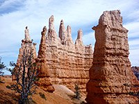
The soft entrada sandstone bedrock hereabouts is variously grey, light brown, very pale green or pure white in color and forms hoodoos ranging in shape from broad and short to tall, slender and tapering, topped either by dark sandstone blocks or unusual boulders of purple conglomerate, composed of small pebbles bonded together. The formations could once be reached by driving along a 4WD track that forks east off Cottonwood Canyon Road, but this is now closed to vehicular traffic and instead the usual approach route is up Wahweap Creek starting at Big Water, a sometimes sandy hike of 4.6 miles. The seasonal creek flows through a wide, shallow canyon, which away from the hoodoos is uninteresting apart from several very short slot canyon tributaries, on the east side.
The (former) vehicular approach to the Wahweap Hoodoos, still open to foot traffic, is along an undesignated track, rough in places, that forks northeast 1.5 miles from the south end of Cottonwood Canyon Road, which joins US 89 between mileposts 17 and 18. This bends eastwards after a few miles, past several junctions and ends after 10.5 miles right beside Wahweap Creek, from where the hoodoos are a short walk south. The alternative access starts via the easternmost of the two side roads into Big Water; this leads through town, where the surface changes to gravel, and descends into the wide valley of the creek, past a fish hatchery and onto a corral at the edge of the sandbanks lining the streamway. This is the 2WD parking area; the track continues another 0.8 miles, crossing the sometimes muddy creekbed and heading north over sandy land to another parking spot, with a BLM notice, beside the confluence with Nipple Creek. A faint track leads into the adjacent streamway, though a long fence (marking the edge of Wahweap Wilderness Study Area) stops most ATVs from proceeding any further; there are just a few even fainter tire marks beyond.
The valley of Wahweap Creek is about a third of a mile across, with the (usually dry) streamway occupying most of the area, winding from side to side. The low cliffs along the edges are reddish to the west and brown to the east, both made of sandstone from the Carmel Formation. The northwards walk from the end of the road to the hoodoos is somewhat monotonous as the valley is straight and the views are little changing, but hike is easy as the ground is level and the surface firm, mostly hard baked mud or small pebbles. The creek itself does not often flow though some pools remain for several weeks after floods. The cliffs on the west side of the valley change to the hoodoo-forming entrada sandstone layer after about 3 miles, beyond a major tributary, and become noticably higher than before, up to 200 feet. Initially the rocks are merely heavily eroded into fissures and tiny pinnacles, but they soon form big hoodoos which stretch for about half a mile, beyond which the cliffs stay high for a while but do not have any more interesting formations.
The rocks forming the cliffs on the west side of the valley are colored light grey, greenish or white, with a layer of conglomerate towards the top, and this forms the caps of most of the hoodoos. This stratum is deep red, purple or dark orange, composed of an aggregate of small pebbles and coarse sand. The hoodoos in the first group have large, thick pillars beneath substantial caprocks, some positioned quite high up the valley side, though most are easily reachable. The second group, after an intervening bushy area on the canyon floor with a little path winding through, is the best, located along the south edge of a little tributary ravine. Here the columns are thinner and more delicate, pure white in color, and striated; the surface has a pretty, rippled texture, as do the undulating mounds beneath and the steeper cliffs above. The contrast of the white pedestals with the orange/purple rocks on top is quite striking. Short hiker-made paths ascend to the base of the biggest formations, and the whole area has many footprints, even though visitation is still low, maybe just a few groups per day at popular times.
There are several little slot canyons along Wahweap Creek, formed by minor tributaries on the east side, including one near the 2WD trailhead and a closely spaced pair 1.4 miles north. The northernmost of these narrows after a short distance becoming too tight to follow at floor level, and the passage is partly blocked by a boulder just ahead but there would appear to be a good short channel beyond, however it is not easy to chimney up here. The second canyon, 500 feet south, also soon becomes enclosed and gains height more gently, in stages via little curving falls, and can be explored more easily, at least up to the base of a higher fall. Both canyons cut through rather dull rocks that are uniform in color, brown or grey, without any striations or thin strata, so are not very photogenic.
The soft entrada sandstone bedrock hereabouts is variously grey, light brown, very pale green or pure white in color and forms hoodoos ranging in shape from broad and short to tall, slender and tapering, topped either by dark sandstone blocks or unusual boulders of purple conglomerate, composed of small pebbles bonded together. The formations could once be reached by driving along a 4WD track that forks east off Cottonwood Canyon Road, but this is now closed to vehicular traffic and instead the usual approach route is up Wahweap Creek starting at Big Water, a sometimes sandy hike of 4.6 miles. The seasonal creek flows through a wide, shallow canyon, which away from the hoodoos is uninteresting apart from several very short slot canyon tributaries, on the east side.

Access to the Wahweap Hoodoos
The (former) vehicular approach to the Wahweap Hoodoos, still open to foot traffic, is along an undesignated track, rough in places, that forks northeast 1.5 miles from the south end of Cottonwood Canyon Road, which joins US 89 between mileposts 17 and 18. This bends eastwards after a few miles, past several junctions and ends after 10.5 miles right beside Wahweap Creek, from where the hoodoos are a short walk south. The alternative access starts via the easternmost of the two side roads into Big Water; this leads through town, where the surface changes to gravel, and descends into the wide valley of the creek, past a fish hatchery and onto a corral at the edge of the sandbanks lining the streamway. This is the 2WD parking area; the track continues another 0.8 miles, crossing the sometimes muddy creekbed and heading north over sandy land to another parking spot, with a BLM notice, beside the confluence with Nipple Creek. A faint track leads into the adjacent streamway, though a long fence (marking the edge of Wahweap Wilderness Study Area) stops most ATVs from proceeding any further; there are just a few even fainter tire marks beyond.


Hike along Wahweap Creek
The valley of Wahweap Creek is about a third of a mile across, with the (usually dry) streamway occupying most of the area, winding from side to side. The low cliffs along the edges are reddish to the west and brown to the east, both made of sandstone from the Carmel Formation. The northwards walk from the end of the road to the hoodoos is somewhat monotonous as the valley is straight and the views are little changing, but hike is easy as the ground is level and the surface firm, mostly hard baked mud or small pebbles. The creek itself does not often flow though some pools remain for several weeks after floods. The cliffs on the west side of the valley change to the hoodoo-forming entrada sandstone layer after about 3 miles, beyond a major tributary, and become noticably higher than before, up to 200 feet. Initially the rocks are merely heavily eroded into fissures and tiny pinnacles, but they soon form big hoodoos which stretch for about half a mile, beyond which the cliffs stay high for a while but do not have any more interesting formations.


The Hoodoos
The rocks forming the cliffs on the west side of the valley are colored light grey, greenish or white, with a layer of conglomerate towards the top, and this forms the caps of most of the hoodoos. This stratum is deep red, purple or dark orange, composed of an aggregate of small pebbles and coarse sand. The hoodoos in the first group have large, thick pillars beneath substantial caprocks, some positioned quite high up the valley side, though most are easily reachable. The second group, after an intervening bushy area on the canyon floor with a little path winding through, is the best, located along the south edge of a little tributary ravine. Here the columns are thinner and more delicate, pure white in color, and striated; the surface has a pretty, rippled texture, as do the undulating mounds beneath and the steeper cliffs above. The contrast of the white pedestals with the orange/purple rocks on top is quite striking. Short hiker-made paths ascend to the base of the biggest formations, and the whole area has many footprints, even though visitation is still low, maybe just a few groups per day at popular times.


Wahweap Creek Slot Canyons
There are several little slot canyons along Wahweap Creek, formed by minor tributaries on the east side, including one near the 2WD trailhead and a closely spaced pair 1.4 miles north. The northernmost of these narrows after a short distance becoming too tight to follow at floor level, and the passage is partly blocked by a boulder just ahead but there would appear to be a good short channel beyond, however it is not easy to chimney up here. The second canyon, 500 feet south, also soon becomes enclosed and gains height more gently, in stages via little curving falls, and can be explored more easily, at least up to the base of a higher fall. Both canyons cut through rather dull rocks that are uniform in color, brown or grey, without any striations or thin strata, so are not very photogenic.


Wahweap Hoodoos - Similar Hikes


All Contents © Copyright The American Southwest | Comments and Questions | Contribute | Affiliate Marketing Disclosure | Site Map