

Mount Ellsworth
Higher of the two peaks in the Little Rockies, the southern component of the Henry Mountains, reached by a sparsely cairned, off-trail route up ridges and steep slopes on the northwest side. Spectacular views from the summit
Length: 3.4 miles
Elevation change: 2,870 feet
Difficulty: Strenuous
Type: One-way, off-trail
Usage: Very low
Season: Spring and fall - hot in summer, snowy in winter
Trailhead: Pull-out along Hwy 276
Rating (1-5): ★★★★★
Elevation change: 2,870 feet
Difficulty: Strenuous
Type: One-way, off-trail
Usage: Very low
Season: Spring and fall - hot in summer, snowy in winter
Trailhead: Pull-out along Hwy 276
Rating (1-5): ★★★★★

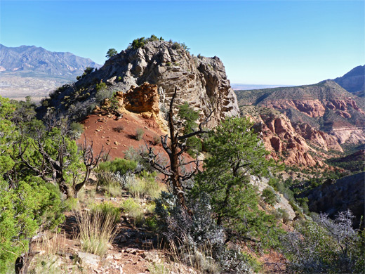
Mount Ellsworth is the largest of the two peaks of the Little Rockies, the smaller southern section of the Henry Mountains, separated from the main group of peaks by a corridor of red rock desert, crossed by Hwy 276. Unlike the northern summits there are no vehicle tracks or maintained trails into the upper reaches of the Little Rockies, but both peaks (the other being Mount Holmes) are within range of a day hike, by route-finding through the lower foothills, which are partly made up of colorful, upturned sedimentary layers, then ascending the steeper, grey, igneous rocks of the higher slopes.
A helicopter-serviced communications tower stands on the summit of Mount Ellsworth, and nearby is a logbook for hikers, entries in which suggest that on average only one person makes the climb each month. Also in the vicinity is a metal box containing water, provisions and other objects, seemingly here for several years. The hike is 3.4 miles in distance, climbing 2,870 feet, but the first 1.6 miles and 950 feet is along a disused road, so the strenuous part is relatively short, and the round trip can be done in four to five hours. For most of the climb the views are to the northwest, looking towards the main group of peaks; the suggested route, which is sparingly marked by cairns, leads to a secondary summit half a mile northeast, where land to the east first comes into view, while the full panorama is only revealed right at the end, after a final climb.
In addition to the tower, the somewhat elongated summit also has a few trees so does not offer an uninterrupted 360 degree view, and much of the red rock land below is rather featureless at this distance, and often hazy, but still the vista is quite spectacular, encompassing such far-away features as Navajo Mountain, Sleeping Ute Mountain and the Aquarius Plateau.
Parking for the hike to Mt Ellsworth is at the start of a little track on the west side of Hwy 276, leading to a seasonal pond, 2.8 miles south of the signed turn-off for Starr Spring Campground. The track is directly opposite another, disused road that leads into the Mount Ellsworth foothills and provides the first half of the route. The old road is not marked on the BLM map of the Henry Mountains but still seems to be open to (4WD) vehicles, however the walk is pleasant enough - initially parallel to the highway for a short distance then up a lengthy ridge to the southeast, heading for a point just north of the summit. Other tracks branch off to the left after about half a mile and right at the one mile mark, after which the track rises more steeply to a saddle, descends into a shallow valley, climbs the far side and ends on a sandy knoll, elevation 6,330 feet. Ahead, the land slopes down slightly to another minor saddle before rising once more; this area is within the band of inclined, sedimentary layers, so the onwards hike involves a few more little descents in between longer climbs, to pass the various strata. Cairns mark the way and a faint path is visible in some places yet the route is not always obvious.
After climbing a lengthy incline, covered in some places by loose stones, the ground dips down again for the last time, to the uppermost red rock layer, before the start of the main part of the ascent, initially up a slope of stones and earth, then a big area of undulating, bare rock. Beyond is a rocky ridgeline, a bushier slope, a second lengthy slickrock section and finally more boulders and bushes as the route approaches the central ridge, running northeastwards from the summit. A short, less steep climb reaches the secondary summit (8,049 feet), from where, turning southwest, the ridge is fairly level, passing another small summit (8,059 feet) and descending a little via a talus slope to a saddle, and finally climbing for the last time, 300 feet up a steep, bushy slope, to the top of Mt Ellsworth.

A helicopter-serviced communications tower stands on the summit of Mount Ellsworth, and nearby is a logbook for hikers, entries in which suggest that on average only one person makes the climb each month. Also in the vicinity is a metal box containing water, provisions and other objects, seemingly here for several years. The hike is 3.4 miles in distance, climbing 2,870 feet, but the first 1.6 miles and 950 feet is along a disused road, so the strenuous part is relatively short, and the round trip can be done in four to five hours. For most of the climb the views are to the northwest, looking towards the main group of peaks; the suggested route, which is sparingly marked by cairns, leads to a secondary summit half a mile northeast, where land to the east first comes into view, while the full panorama is only revealed right at the end, after a final climb.
In addition to the tower, the somewhat elongated summit also has a few trees so does not offer an uninterrupted 360 degree view, and much of the red rock land below is rather featureless at this distance, and often hazy, but still the vista is quite spectacular, encompassing such far-away features as Navajo Mountain, Sleeping Ute Mountain and the Aquarius Plateau.


Mt Ellsworth Foothills
Parking for the hike to Mt Ellsworth is at the start of a little track on the west side of Hwy 276, leading to a seasonal pond, 2.8 miles south of the signed turn-off for Starr Spring Campground. The track is directly opposite another, disused road that leads into the Mount Ellsworth foothills and provides the first half of the route. The old road is not marked on the BLM map of the Henry Mountains but still seems to be open to (4WD) vehicles, however the walk is pleasant enough - initially parallel to the highway for a short distance then up a lengthy ridge to the southeast, heading for a point just north of the summit. Other tracks branch off to the left after about half a mile and right at the one mile mark, after which the track rises more steeply to a saddle, descends into a shallow valley, climbs the far side and ends on a sandy knoll, elevation 6,330 feet. Ahead, the land slopes down slightly to another minor saddle before rising once more; this area is within the band of inclined, sedimentary layers, so the onwards hike involves a few more little descents in between longer climbs, to pass the various strata. Cairns mark the way and a faint path is visible in some places yet the route is not always obvious.

The Upper Slopes
After climbing a lengthy incline, covered in some places by loose stones, the ground dips down again for the last time, to the uppermost red rock layer, before the start of the main part of the ascent, initially up a slope of stones and earth, then a big area of undulating, bare rock. Beyond is a rocky ridgeline, a bushier slope, a second lengthy slickrock section and finally more boulders and bushes as the route approaches the central ridge, running northeastwards from the summit. A short, less steep climb reaches the secondary summit (8,049 feet), from where, turning southwest, the ridge is fairly level, passing another small summit (8,059 feet) and descending a little via a talus slope to a saddle, and finally climbing for the last time, 300 feet up a steep, bushy slope, to the top of Mt Ellsworth.


Mt Ellsworth Map

Mount Ellsworth Wildflower
 Small wirelettuce |
Mount Ellsworth - Similar Hikes


All Contents © Copyright The American Southwest | Comments and Questions | Contribute | Affiliate Marketing Disclosure | Site Map